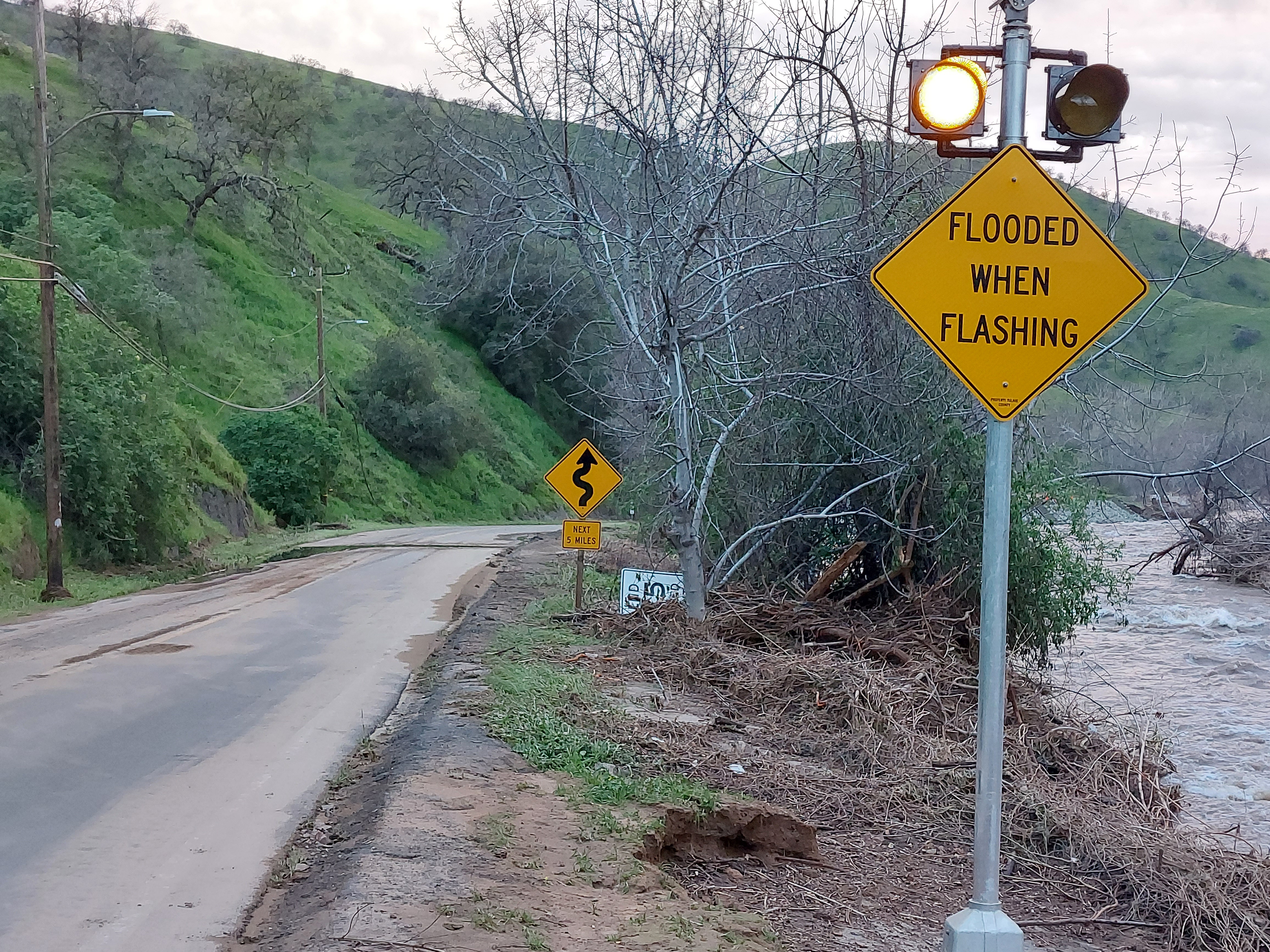
Reservation Road.
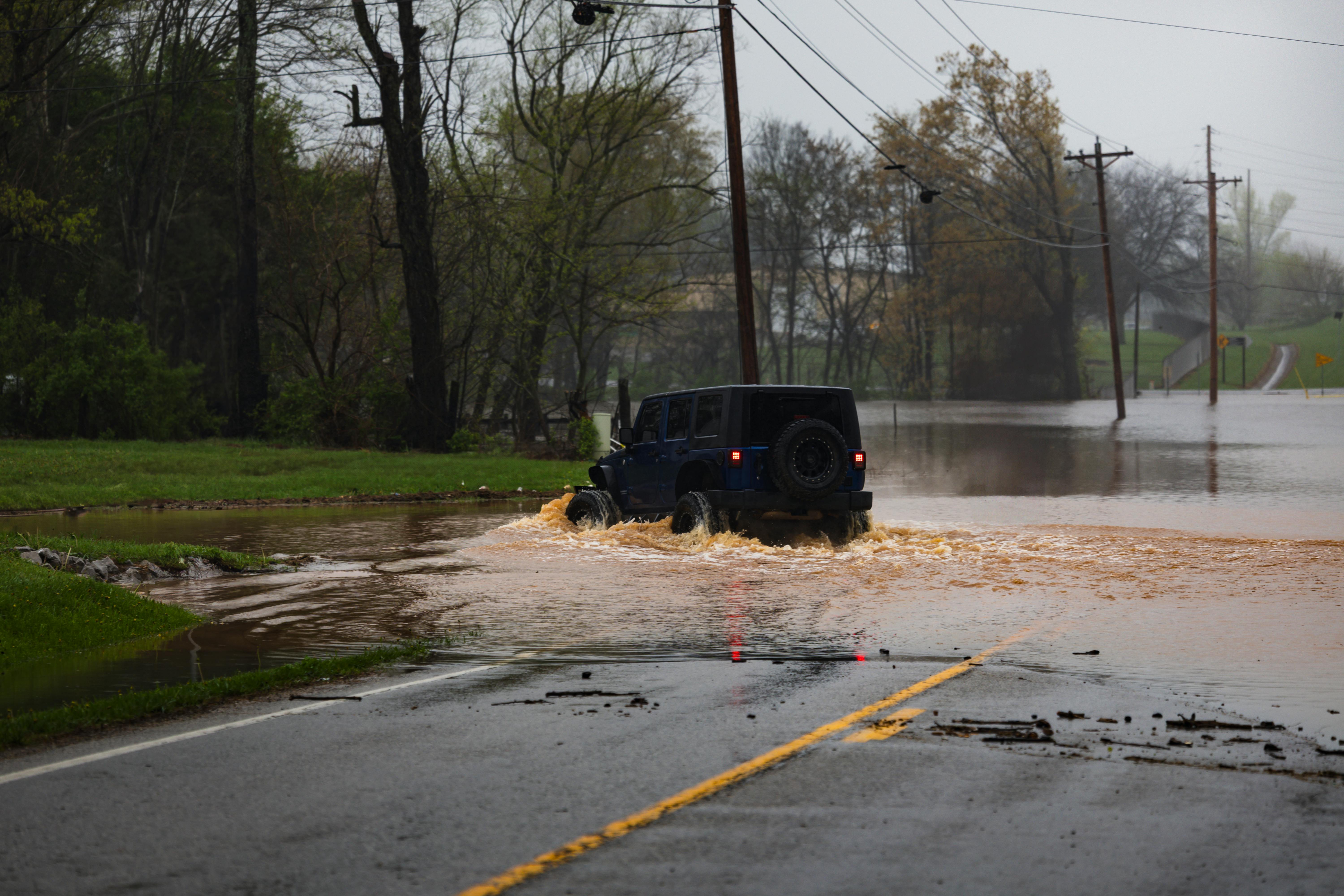
Reservation Road is the only paved route connecting the Tule River Indian Reservation and the Eagle Mountain Casino to the outside world. For roughly one mile, the road threads through a narrow granite canyon along the Tule River. When the river swells during winter storms or upstream releases, the canyon becomes a trap: blind curves limit a driver's sight distance to seconds, the granite walls block cellular coverage, and floodwater can cross the roadway with very little warning.
A granite canyon that gives drivers seconds of warning.
For one mile, the road is pinched between the river and near-vertical granite walls. There are several blind curves, and the river channel sits immediately adjacent to — and in places below — the pavement. During heavy rainfall or rapid snowmelt, the river rises quickly and can overtop the road at multiple low points. Because the curves limit sight distance and the canyon kills radio and cellular signal, a driver entering the canyon may not see standing water or debris until they are already committed to the section.
Drivers have been stranded, vehicles have been swept off the road, and lives have been lost. Tulare County engaged ToltHawk to design and deploy an early-warning system tailored to this exact corridor.
Why the standard solutions did not fit.
A USGS streamgage is not an alerting platform
The nearest gage sits a few miles upstream. It is an excellent hydrologic monitor, but it was never designed to trigger roadway signals or push SMS to county staff when a threshold is crossed.
There is no cellular service in the canyon
Carrier maps suggest signal at the canyon mouth, but inside the granite walls there is effectively none. Anything relying on LTE or 4G modems for backhaul was a non-starter.
Static signage gives no live information
"Flooded When Wet" signs are already in place, but drivers habituate to standing signs and continue past them in clear weather.
A staffed roadblock is not feasible
The corridor is remote, the road is low-volume, and conditions often arrive at night and develop within minutes.
Four layers, from canyon to responder.
The deployed system has four layers: in-canyon sensing, automatic roadside warning, satellite backhaul to the cloud, and out-of-canyon notification to people.
Layer 1 — In-canyon sensing
River-stage sensors monitor the Tule River at the upstream end of the corridor for the earliest indication that flow is approaching threshold, while roadway water-presence sensors detect any trace of water crossing the pavement at known low points. Every device is solar-powered with battery backup sized for extended storm and overcast conditions.
Layer 2 — Automatic roadside warning
Two Tapco LED flashing beacons, one at each canyon entrance, are each wired to a ToltHawk trigger switch driven by the cloud alerting logic. When sensor data crosses threshold, the switch energizes the beacon automatically — no human in the loop is required for the signal to start flashing.
Layer 3 — Satellite backhaul
Every device in the canyon uploads its data over satellite. Because uplink does not depend on cellular service, sensors can be placed wherever the hydrology and road geometry require them. The link is bidirectional, which is what lets the cloud platform send the trigger command back down to the beacon switches.
Layer 4 — Notification to people
In parallel with the automatic beacon trigger, the platform sends SMS to on-call public works and emergency-services personnel and email to a wider distribution of supervisors, county leadership, and tribal liaisons. Beacons, SMS, and email are intentionally redundant — each reaches a different audience through a different channel.
What happens, from threshold to action.
- 1Sensor reading exceeds thresholdIn-canyon device (river stage or roadway water)Seconds
- 2Reading uploaded via satelliteCanyon to ToltHawk cloudSeconds
- 3Trigger command issuedToltHawk cloud platformSeconds
- 4Beacon turns on at canyon entranceTapco signal via ToltHawk switchSeconds
- 5SMS dispatched to on-call staffToltHawk cloudWithin ~1 minute
- 6Email dispatched to wider distributionToltHawk cloudWithin ~1 minute
- 7County staff act on the alertField / EOCMinutes
A warning system that proves it still works.
A warning system that fails silently is worse than no system at all, because it creates the illusion of protection. Every sensor and signal reports its own health to the cloud on a regular cadence — battery voltage, signal quality, last-successful-upload time, and beacon-circuit continuity. County employees can also manually trigger and test the beacons and the full alerting pipeline at any time.
- Continuous self-health checks raise a maintenance alert — on a separate channel from flood warnings — the moment a device misses its check-in or reports a degraded condition.
- Scheduled manual tests verify the beacons, the satellite link, and the SMS/email distribution end to end.
- Routine testing familiarizes local drivers with what the warning looks like and builds operator confidence under stress.
What changed.
- A previously unprotected one-mile corridor now has automatic, in-the-moment driver warning at both entrances during flood conditions.
- County and emergency-services staff receive SMS and email notifications from inside a canyon that has no cellular coverage, courtesy of satellite-only sensor uplinks.
- Routine manual testing is now part of operations, so the warning pathway is exercised regularly rather than relied upon only during an emergency.
- The same platform supports tribal partners and the casino’s operations team, so traffic-management decisions can be coordinated across jurisdictional boundaries.
Our 16 ToltHawk sensors paid for themselves the first month we installed them in the field.
APWA California Central Chapter, 2022 awards.
The project was recognized by the American Public Works Association (APWA) California Central Chapter in its 2022 awards cycle, and has been cited by public works departments across California as a model for satellite-backed flood warning on remote, signal-denied corridors where the conventional toolkit does not match the geography or the threat.
What this corridor taught the field.
Match the backhaul to the geography
Architecting around satellite from the start — rather than treating cellular as primary with satellite as a fallback — let sensor placement be optimized for hydrology and road geometry, and removed the failure modes of an unreliable cellular link.
Automate the time-critical step; notify humans in parallel
The roadside beacon protects the driver already in the canyon, in seconds, with no human in the loop. SMS and email protect the broader response, in minutes, with humans firmly in the loop — on separate paths.
Build the test pathway as carefully as the alert pathway
Continuous self-health checks and routine manual testing are how the system continues to deserve the trust of operators and the public over years of operation.
Respect the constraints of the people on the road
A driver rounding a blind curve has seconds, not minutes, and no smartphone signal. The right interface for that driver is a flashing light at the canyon entrance — not an app.
The project at a glance.
- Client
- County of Tulare, California
- Solution provider
- ToltHawk Sensor Networks
- Location
- Reservation Road / Tule River canyon, Tulare County, CA
- Served community
- Tule River Indian Reservation, Eagle Mountain Casino, residents and visitors
- Protected length
- Approximately one mile through a granite canyon
- Primary hazard
- Flash flooding from the Tule River across the roadway
- Sensing
- River-stage and roadway water-presence sensors at key points
- Roadside warning
- Two Tapco LED flashing beacons, automatically triggered
- Backhaul
- Satellite (sole communications medium available in the canyon)
- Notification
- Roadside beacons, SMS to on-call staff, email to wider distribution
- Health monitoring
- Continuous self-checks on every sensor and signal
- Recognition
- APWA California Central Chapter, 2022 awards

Ready to Monitor
What Matters?
Get a personalized demo and see how ToltHawk sensors can protect your community.